

Handheld Satellite Communicators with GPS Navigation
- Rugged handheld satellite communicators enable two-way text messaging via 100% global Iridium® satellite network (satellite subscription required)
- Trigger an interactive SOS to the 24/7 search and rescue monitoring center
- Track and share your location with family and friends
- Pair with compatible mobile devices using the free Earthmate® app for access to downloadable maps¹, U.S. NOAA charts, color aerial imagery and more
- inReach Explorer+ device adds preloaded DeLorme® TOPO maps with on-screen GPS routing plus built-in digital compass, barometric altimeter and accelerometer

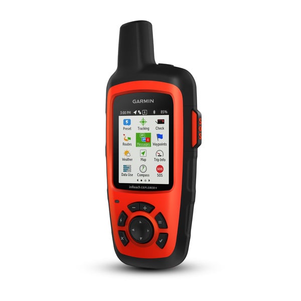
You may venture off the grid, but you can still stay in touch — as long as you’re carrying an inReach SE+ or inReach Explorer+. These handheld satellite communicators are designed for the outdoor enthusiast who wants to roam farther and experience more — without compromising their loved ones‘ peace of mind. From backcountry experiences to international adventures, inReach provides communication, location sharing, navigation and critical SOS functions for anyone who loves getting away from it all, on land, water or in the skies.
No Cell Tower? No Phone Service? No Problem.
inReach SE+ and Explorer+ give you all the tools to stay totally connected. You don’t have to worry about being within range of a cell tower — or encountering spotty coverage in fringe zones or blackout areas. Your inReach communicator offers two-way messaging via the global Iridium satellite network.
Affordable, Flexible Satellite Airtime Plans
To access the Iridium network and communicate with your inReach SE+ or Explorer+ device, an active satellite subscription is required. Depending on your usage level, you can opt for an annual contract package or flexible month-to-month airtime plan.
Unlimited Cloud Storage and Trip Planning are Included
Every inReach device comes with free access to a cloud-powered Garmin Explore website to plan your trips with routes and waypoints, create preset messages and quick texts, sync and manage your device settings, update your firmware, download additional TOPO maps, link your social media accounts, store all your location tracking data and much more.
Built for the Rugged Backcountry
Tough, durable, impact resistant and water-rated to IPX7, the inReach SE+ and Explorer+ handhelds are built to keep you up and running — no matter what the elements throw at you. An internal, rechargeable lithium battery comes standard on both units so you can count on long battery life in every mode of operation (up to 100 hours at 10-minute tracking mode (default); up to 75 hours at 10-minute tracking with 1-second logging; up to 30 days at the 30-minute interval power save mode; and up to 3 years when powered off). Recharge via the standard microUSB power cable or optional in-vehicle 12 V charger.
Additional Aviation Services
Your inReach Explorer+ is also a supported device for the Lockheed Martin Flight Services (LMFS) Adverse Condition Alerting Service (ACAS), Surveillance-Enhanced Search and Rescue (SE-SAR) and Enhanced Special Reporting Services (eSRS). If you register for ACAS information, alerts provided via LMFS prompt you to call for an abbreviated briefing to address any specific adverse condition situation that might affect your flight-planned routing. Likewise, automatic monitoring provided by the SE-SAR service enables the system to identify potential flight emergency situations and/or signals to promptly initiate search and rescue procedures for your aircraft.
¹Preloaded DeLorme TOPO maps are not compatible with other Garmin devices. Other Garmin maps not compatible with this device.
The Bluetooth word mark is owned by the Bluetooth SIG, Inc. and any use of such marks by Garmin is under license. Apple is a trademark of Apple Inc., registered in the U.S. and other countries. Android™ is a trademark of Google Inc.
General |
|
| Physical dimensions | 2.7″ x 6.5″ x 1.5″ (6.8 x 16.4 x 3.8 cm) with keypad and SOS door bump |
|---|---|
| Display size | 1.4″W x 1.9″H (3.5 x 4.7 cm); 2.31″ diag (5.9 cm) |
| Display resolution | 200 x 265 pixels |
| Display type | transflective color TFT |
| Weight |
7.5 oz (213.0 g) |
| Battery type | Rechargeable internal lithium-ion |
| Battery life |
Up to 100 hours at 10-minute tracking mode (default) |
| Water rating | IPX7 |
| High-sensitivity receiver | |
| Interface | micro USB |
| Memory/History | 2 GB (user space varies based on included mapping) |
Maps & Memory |
|
| Preloaded maps |
yes. The North America SKU of the inReach Explorer+ comes preloaded with a 1:24k map of Garmin Yarmouth (Former DeLorme) North America data of the U.S. and Canada. Mexico also is included at a 1:125k scale (derived from Garmin Yarmouth’s Digital Atlas of the Earth). |
|---|---|
| Ability to add maps | |
| Basemap | |
| Includes detailed hydrographic features (coastlines, lake/river shorelines, wetlands and perennial and seasonal streams) | |
| Displays national, state and local parks, forests, and wilderness areas | |
| Waypoints/favorites/locations | 500 |
| Tracks | single dynamic track |
| Track log | single auto overwrite track log |
| Routes | 20, 200 points per route |
Sensors |
|
| GPS | |
|---|---|
| Barometric altimeter | |
| Compass | Yes (tilt-compensated 3-axis) |
| GPS compass (while moving) |
Daily Smart Features |
|
| Weather |
|---|
inReach® Features |
|
| Interactive SOS | |
|---|---|
| Send and receive text messages to SMS and email | |
| Send and receive text messages to other inReach device | |
| Exchange locations with other inReach device | |
| MapShare compatible with tracking | |
| Virtual keyboard for custom messaging | |
| Send waypoints to MapShare during trip | |
| Send route selection to MapShare during trip |
Outdoor Applications |
|
| Compatible with Earthmate | |
|---|---|
| Garmin Explore website compatible |
Connections |
|
| Wireless connectivity |
yes (BLUETOOTH®) |
|---|
- inReach Explorer+
- Preloaded with TOPO
- USB cable
- Carabiner clip
- Documentation